I got my iPhone a week before we got the RV. How anyone RVes without one is beyond me.
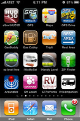
The second page of apps is reserved entirely for my RV and Navigation tools. I'll probably eventually delete about four or five of the redundant apps. I'll test to figure out which are my favorite. My iPhone is almost full with apps, so app space is a premium for me. The rest of the storage space on my iPhone is devoted to audiobooks and podcasts. I'm hoping the a future iPhone OS upgrade will enable users to put many more than just 11 pages of apps on their phone.
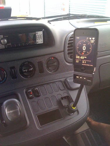
When we're driving in the RV, I keep the iPhone mounted on a Griffin Technologies RoadTrip FM Broadcaster (with "SmartScan"):
 The RoadTrip broadcasts whatever is playing on my iPhone to the radio. Sound quality is excellent. I have rare instances of slight static, but it's usually happens under lots of high tension electric wires. If I put the iPhone on the RoadTrip with the earphones plugged in, I can answer calls and talk on the phone and the RoadTrip will still broadcast to the radio. If I don't have the earphones plugged in at first, then plug them in, I can listen to audio without it broadcasting to the radio. This is a good option if I want to listen to an audiobook without disturbing anyone. Of course, I could just turn the radio off, I guess. Either way, no calls are ever broadcast over the radio.
The RoadTrip broadcasts whatever is playing on my iPhone to the radio. Sound quality is excellent. I have rare instances of slight static, but it's usually happens under lots of high tension electric wires. If I put the iPhone on the RoadTrip with the earphones plugged in, I can answer calls and talk on the phone and the RoadTrip will still broadcast to the radio. If I don't have the earphones plugged in at first, then plug them in, I can listen to audio without it broadcasting to the radio. This is a good option if I want to listen to an audiobook without disturbing anyone. Of course, I could just turn the radio off, I guess. Either way, no calls are ever broadcast over the radio.I've also tried the Griffin WindowSeat with the iTrip. I like that I can also use it in landscape mode. The only thing I don't like about the WindowSeat is I have to take off my iPhone case to put it in the WindowSeat cradle. I haven't decided which I like better, but so far I use the RoadTrip the most.
From their website:
Key features:
- HUD MODE
- SHORT TIME WEATHER FORECAST
- EDITABLE FIXED SPEED CAMERAS DATABASE
- EDITABLE RED LIGHT CAMERAS DATABASE for USA, Australia and Canada
- IPOD PLAYLIST REMOTE CONTROL;
- current speed
- average speed,
- time,
- elapsed trip time,
- heading,
- altitude,
- your location on the map (Street and Satellite image Google maps supported),
- weather forecast for nearest 48 hours the with 3-hour time interval,
- maximum reached speed (during the current trip or all your trips), maximum altitude and maximum distance to the starting point of your trip.
- current playing music track;
- positions of the nearest known speed cameras within an adjustible range
- it's speed limit (if known)
A newer version I've downloaded has a small map that follows where you are. The weather information come out of Norway, and tends to be about 10 degrees off here in Florida. I like that I can adjust the speed limit warnings. The feedback helps keep gas mileage under control.
Another update since the picture above changes the GPS MotionX to GPS Sport MotionX. This app is intended for adventure, tracking, and recording trail rides/hikes. Since we'd be doing some hiking on our trips eventually, I keep this app on the RV page.

Google Maps for iPhone is the next app, and still my main GPS and direction app. It integrates well with everything on the iPhone. It has taken us on some off-beat paths where we were really glad it did. In Pennsylvania and West Virgina, we would have missed some really nice sites if we'd just used a map.
GPS Drive MotionX is another MotionX app.

It's a turn-by-turn GPS direction program. This one uses Bing as it's map source. The best thing about it is the price: $2.99, with the optional voice subscription at $29.99 a year. Apps like Tom-Tom are $99, big programs, and sometimes a bit out of date. The trade off is with GPS Drive you have to be on the network to get a map. Edge network can be VERY slow to update your tracking. Tom-Tom doesn't have to be on the network. I may eventually try the Tom-Tom, but I don't need it quite yet. So far, I'm really satisified with MotionX apps.
GasBuddy is a website as well as an app.

I've set my GasBuddy app to look for diesel. So far, it's been very accurate and up to date. This app is a must for saving money on Diesel, or finding the closest pump when you're running on the memory of fumes.
Gas Cubby was recommended by the Apple Staff, and had excellent reviews. You can keep records of pretty much everything with regard to the vehicle. I use it mostly to track miles per gallon. I like being able to track the costs per mile option, which includes all vehicle related expenses. The biggest problem of using it is the time it takes to put in the information. When you're on the road, you'll tend to keep the receipts and do it later. In realityIn the future, I'll get a scangauge2, and probably won't need to use this app as much.

TripIt Is an a social trip planning and itinerary site. You can setup a trip and share it with people you choose on TripIt. Kind of like LinkedIn for travelers. There is also a mobile TripIt website available. I haven't used it that much, and this would probably be one of the first apps I'd delete.
RestArea will list and map the rest area's closest to you, and the amenities they offer. It will tell you exactly how far you are from a specific rest area.
 ezLevel, iWoMoSet, and iHandy Level are all leveling apps. Once they are calibrated, you can use the app to help level your RV. The iWoMoSet was orginally in German, and is difficult to use, but the default dimension are set exactly for our Winnebago View. The ezLevel and iHandy Level apps have a flat level. Here's a screenshot of the exLevel:
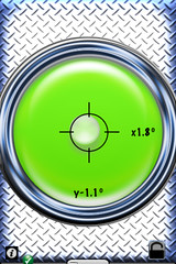
When we get to a campsite or overnight parking area, I set my iPhone and the floor next to the drivers seat. I make adjustments (either leveling blocks or different parking places) to get as comfortably level as possible. Once I'm done, I put the iPhone on the flat surface in the refrigerator to see if it's close enough. Other than comfort, the fridge is the main reason to get as level as possible. As long as I'm pretty much in the circle, the RV is level enough.
ZipFinder is a GPS zip code location finder. This app really helps in using the overnightrvparking.com website on the road. You'll need a membership to overnightrvparking to use the website, but if you're on a long trip and don't need to use a campground every night, the website can really help. I use zipfinder to get the zipcode of where I am, the put the zip in the overnightrvparking search too. I really hope someone works with the overnightrvparking site on either a mobile version, or an iphone app.
AroundMe finds all kinds of things near your current location. We use it mostly to find the nearest Grocery Store or Super Market. When you're in a city, this app is a real time-saver. Driving time, mostly.

OffLeash is an app that will find the nearest Dog Park. If you're a dog owner, you'll love this app. It's by Eukanuba, and it's free. Even though many campgrounds have a dog area, they tend to be small, and not many other dogs to socialize with. Our dogs love dog parks, and love to be off leash in one.
Continuous Traveler RVParks app in a must have for the RVer. This app will find our current location, then show you the closest campgrounds near you. I even use this app to find campgrounds for places were planning to go. You can find a campground, the look at the location, the website, even call from the contact list. Members of the website can add and edit campgrounds. The app started at $14.99, and is now $4.99. For the RV it's a huge bargin. The developer does frequent updates to both the app and the database.
RVCompanion is a new app for me. The main reason I purchased it was to test the leveler section, and the procedures section. I need to use this app a bit more before I can really do a decent review on it.
1 comment:
Great article...I will have to check out some of the iPhone apps that you highlighted. My wife and I bring along dueling iPhones when we're out camping, and like you we can't seem to make it through the trip without using a dozen or more apps along the way. Here are our picks for iPhone camping apps...check it out and see if any we like are useful to you!
Post a Comment